Map of Europe (1877)
This map shows Europe in 1877 An interesting chart, as it includes the changes after the Franco-Prussian War.
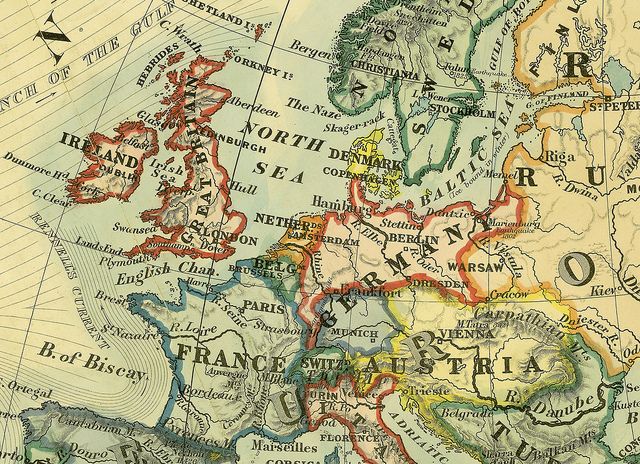
By PDb Maps|2017-10-11T09:20:24+11:00May 21, 2015|Austria, Austro-Hungarian Empire, Europe, Europe Maps, France & Colonies, Great Britain, History, Maps, Scandinavia|
This map shows Europe in 1877 An interesting chart, as it includes the changes after the Franco-Prussian War.
By PDb Maps|2017-10-11T09:20:40+11:00Jan 18, 2015|British Empire, Europe Maps, France & Colonies, Germany & Colonies, Great Britain, History, Hitler, Maps, Military, Third Reich, United States, United States of America, World War II|
For collectors of D-Day Stamps, this map gives detailed information of the D-Day landings of 1944.
By PDb Maps|2017-10-11T09:20:40+11:00Jan 18, 2015|Europe Maps, German States, Maps|
This map gives much detail for collectors and postal historians of Prussia and German States in surrounding areas. It shows
By PDb Maps|2017-10-11T09:20:48+11:00Dec 20, 2014|Europe, Europe Maps, History, Maps, Military, World War II|
Other Europe Maps

By PDb Maps|2017-10-11T09:20:50+11:00Nov 10, 2014|Europe, Europe Maps, German States, Germany & Colonies, History, Maps|
Here is a very useful map of Prussia (Germany) showing changes to its borders from 1871 (Unification) to 1920 (Republic).
By PDb Maps|2017-10-11T09:20:54+11:00Sep 13, 2014|Austria, Austro-Hungarian Empire, Bohemia, Bosnia-Herzegovina, Croatia, Europe Maps, History, Hungary, Maps, Serbia (Servia)|

By PDb Maps|2017-10-11T09:21:02+11:00Jul 10, 2014|Europe, Europe Maps, Germany & Colonies, History, Maps, World War I|
This map shows Europe after the post World War One Settlement (the Locarno Conference) in December 1925. By 1925, Germany
By PDb Maps|2017-10-11T09:21:03+11:00Jul 2, 2014|Europe Maps, France & Colonies, History, Maps, Military, World War I|

By PDb Maps|2017-10-11T09:21:03+11:00Jun 30, 2014|Europe, Europe Maps, History, Maps, World War I|
This is a very useful map for students and postal historians showing Europe in 1914. It shows the Entente, the

By William Cochrane|2017-10-11T09:21:04+11:00Jun 8, 2014|Europe Maps, Germany & Colonies, History, Hitler, Maps, Military, Ryukyus, Third Reich|
This map shows Ukraine occupied by Germany (Reichskommissariat of Ukraine).Jun 1941 - 2 Feb 1944. German Commander: 25 Jun 1941
By PDb Maps|2017-10-11T09:21:25+11:00May 23, 2014|British Commonwealth, Europe Maps, Great Britain, History, Maps|

By PDb Maps|2017-10-11T09:21:32+11:00Mar 25, 2014|Europe, Europe Maps, Germany & Colonies, History, Inflation Issues, Maps, Uncategorized|
This map shows the Weimar Republic and its capitals in 1925. Collectors of hyperinflationary stamps of this period should find

By William Cochrane|2017-10-11T09:21:37+11:00Mar 19, 2014|Europe, Europe Maps, History, Maps, Serbia (Servia)|
This map shows the expansion of Serbia in 1913. This should prove a useful map for collectors of Serbia and

By PDb Maps|2017-10-11T09:21:38+11:00Mar 11, 2014|Europe, Europe Maps, Maps, Slovakia|
Given we are always adding new issues from Slovakia, we thought our readers might appreciate a contemporary map of the
By PDb Maps|2017-10-11T09:21:57+11:00Jan 9, 2014|Balkans, Europe Maps, History, Maps|